Gravimetric map at 1:1.250.000
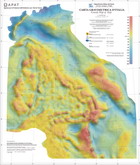
A new gravimetric map of Italy and surrounding seas at 1:1,250,000 scale was realized using land and marine data respectively extracted from the databases of ISPRA - Department of Soil and OGS National Institute of Oceanography and Experimental Geophysics - Department of Geophysics of the Lithosphere. The totality of data was related to IGSN71 (International Gravity Standardization Net) and the normal gravity was calculated using the formula of 1980. For the ground data has been processed the Bouguer anomaly using a density of 2.67 g/cm3; topographic correction has been extended to a radius of 166,736 km from the station point. The processing of marine data, most of which was acquired along lines of navigation, was made only calculating the Anomaly in Free Air. A grid was obtained interpolating the totality of the gravimetric data on a regular grid with an interval of 1 km; the resulting map is based on the contour of this grid with shaded relief representation in colors.
The map contains information about the medium-scale gravity anomalies for geophysical studies related to the deep geology and the tectonic elements of Italian territory. It can be considered as a useful tool for the identification of major structural lineaments and to outline the main geological features at regional scale.
We thank ENI S.p.A. - Exploration & Production Division, for permission to use the gravity data of their properties and residing in the database ISPRA, and BRGM CDG/MA for providing the Corsica gravity data onshore.
For information please contact: Dr. Fernando Ferri (ISPRA-ITS-GFI)
- View the Gravimetric Map at 1:1,250,000 scale
- View the Illustrative Notes of the Gravimetric Map at 1:1,250,000 scale
The map is for sale at 10,00 euro, following the instructions here.