PNRR MER (Marine Ecosystem Restoration)
The PNRR MER Project (Marine Ecosystem Restoration) is the largest project on the sea in the context of the National Recovery and Resilience Plan, which sees ISPRA as the implementing body and the Ministry for the Environment and Energy Security as the administration holder of the financing of 400 million euros for 2022-2026. The MER envisages interventions for the restoration and protection of the seabed and marine habitats, the strengthening of the national system for the observation of marine and coastal ecosystems and the mapping of coastal and marine habitats in Italian waters with the acquisition of a new oceanographic naval unit , equipped with highly technological equipment capable of probing the seabed up to 4000 m and very high resolution acoustic instrumentation
Some of the main activities foreseen by the Project:
- The reconstruction of banks of the European flat oyster (Ostrea edulis) in as many as 5 regions of the Adriatic: Friuli Venezia-Giulia, Veneto, Emilia Romagna, Marche and Abruzzo. Oysters have the ability to build real limestone reefs, the equivalent of tropical coral reefs at our latitude
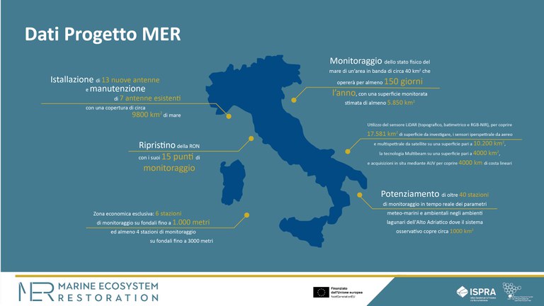
- Another unprecedented element of the Project is the mapping of the coastal habitats of the entire Italian coast. Sensors capable of covering 581 km2 of surface to be investigated will be used, airborne and satellite sensors on an area of 10,200 km2, Multibeam technology on an area of 4000 km2 and in situ acquisitions using an Autonomous Underwater Vehicle (a kind of drone underwater) to cover 4000 km of linear coastline
- Monitoring using coastal HF radar antennas involves the installation of 13 new antennas and the maintenance of 7 existing antennas with a total sea coverage of approximately 9800 sq km.
- Construction of a new national network of offshore buoys for monitoring wave motion, sea currents and weather parameters, adding to the already existing National Wave Measurement Network (RON). It is planned to install at least 6 monitoring stations at depths of up to 1,000 meters and at least 4 monitoring stations at depths of up to 3,000 meters several miles from the coast, within the future Exclusive Economic Zone (EEZ)
- The Ondametric Network will be restored with its 15 monitoring points, distributed along the national coasts, which will provide fundamental elements for the climate change scenarios that will affect our peninsula in the coming years and decades
- About 90 seamounts will be mapped for deep habitats, located in the Ligurian Sea, the Upper and Lower Tyrrhenian Sea, the Sardinian Sea, the Ionian Sea and the Southern Adriatic Sea, for an estimated surface area of about 14,000 km2.
- ISPRA data show that 86.5% of waste at sea is linked to fishing activities and 94% of these are abandoned nets. The MER project involves the identification and restoration of at least 15 areas where there are abandoned fishing and/or aquaculture gear, preserving the local fauna and flora.


