Landslides and floods: ISPRA's activities
On 27 August 2024, the provinces of Caserta, Benevento and Avellino were hit by strong storms that caused landslides and rivers of mud in various locations. Irpinia was particularly affected where in San Felice Cancello the streets of the hilly hamlet of Talanico were invaded by a river of mud and debris.
Among the institutional tasks of ISPRA is the collection, processing and dissemination of maps and data on hydrogeological instability referring to the entire national territory, making them available to the country for risk prevention and mitigation.
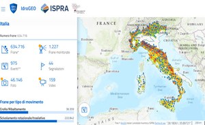
In particular, ISPRA in collaboration with the Regions and Autonomous Provinces, has realized the Inventory of Landslide Phenomena in Italy, in which, to date, over 634,000 landslides have been recorded, representing 2/3 of those in Europe.
.
Every three years ISPRA publishes the Report on hydrogeological instability in Italy which constitutes the official reference framework on the hydrogeological hazard and risk for our country.
The data tell us that the 94% of Italian municipalities are at risk from landslides, floods or coastal erosion, 1.3 million inhabitants are at risk of landslides and 6.8 million inhabitants at risk of floods (ISPRA Report, 2021). We are working on the 2024 edition which will be published early next year.
All data is published on the national IdroGEO platform, an easy tool to use, even with smartphones, to promote greater awareness of the risks affecting one's territory and informed decisions on where to buy one's home or locate new economic activities.
In situ monitoring of landslides is essential to deepen knowledge of landslide phenomena, evaluate the evolution of ongoing phenomena (forecast), support the design of stabilization works and verify their effectiveness over time, correctly plan the territory, activate procedures to alert the population.
In 2021, ISPRA created the National Registry of in situ landslide monitoring systems in order to survey the monitoring networks on the national territory. It is managed in collaboration with Regions, Autonomous Provinces and ARPA and contains information on location, managing entity, monitoring purpose (cognitive/alert), system status (active/decommissioned/under construction), type of acquisition (manual/ continuously), type of monitoring instrumentation.

