Istituto Superiore per la Protezione
e la Ricerca Ambientale

Cerca

ITaly HAzards from CApable faulting

Italy is located in the central sector of the Mediterranean basin, characterized by a complex geodynamic mosaic, currently characterized by areas of convergence and extension with different degrees of activity. Mostly, the crustal deformation is distributed along systems of faults recognizable on the surface, but sometimes buried, and is pinpointed by seismic events.
The numerous observations carried out so far in the world indicate that the phenomenon of the surface fault deformation is common for crustal earthquakes starting from magnitude around 5.5-6, with offsets and rupture lengths increasing with magnitude. In Italy, many catastrophic historical earthquakes (e.g., 1783 in Calabria, 1915 in the Fucino Basin, 1980 in Irpinia, with magnitudes around 7), have been associated with superficial faulting phenomena with around one meter of displacement. Paleoseismological studies have made it possible to recognize similar phenomena in the late Pleistocene-Holocene along several tectonic structures previously considered inactive, demonstrating a greater frequency than assumed before. Surface faulting can cause serious damage to buildings and infrastructures and therefore represents a significant hazard, particularly in the numerous densely populated and industrialized areas of the Italian territory. Consequently, the in-depth knowledge and precise spatial location of faults capable of producing a significant permanent tectonic deformation at or near surface (capable faults) plays a key role in risk mitigation. The importance of assessing the hazard in terms of ground rupture is also indicated in Eurocode 8 (in part 5 on foundations). For these reasons, the Geological Survey of Italy - ISPRA has developed the ITHACA project (ITaly HAzard from CApable faults), which summarizes the available information on capable faults affecting the Italian territory. ITHACA represents, therefore, a fundamental tool for: a) environmental and seismic hazard analysis, b) understanding recent landscape evolution, c) territorial planning and d) Civil Protection emergency management. It also supports the scientific research in the analysis of geodynamic processes. Although most of the movements along capable faults occur in association with seismic events, rarely, the slip can occur slowly, i.e. aseismically (creep). Deformations at or near surface along brittle structures can also be induced in Italy by endogenous phenomena not directly related to crustal tectonics:

  • Volcanic activity
  • Saline tectonics
  • Sediment differential compaction.

For further clarifications, please contact the Geological Survey of Italy at email: ithaca@isprambiente.it.
Access to the ITHACA database (from the Portal of the Geological Survey of Italy) via the link.

Ithaca on the Geological Survey of Italy Portal

Ithaca Mapviewer


Italy is located in the central sector of the Mediterranean basin, characterized by a complex geodynamic mosaic, currently characterized by areas of convergence and extension with different degrees of activity. Mostly, the crustal deformation is distributed along systems of faults recognizable on the surface, but sometimes buried, and is pinpointed by seismic events.
The numerous observations carried out so far in the world indicate that the phenomenon of the surface fault deformation is common for crustal earthquakes starting from magnitude around 5.5-6, with offsets and rupture lengths increasing with magnitude. In Italy, many catastrophic historical earthquakes (e.g., 1783 in Calabria, 1915 in the Fucino Basin, 1980 in Irpinia, with magnitudes around 7), have been associated with superficial faulting phenomena with around one meter of displacement. Paleoseismological studies have made it possible to recognize similar phenomena in the late Pleistocene-Holocene along several tectonic structures previously considered inactive, demonstrating a greater frequency than assumed before. Surface faulting can cause serious damage to buildings and infrastructures and therefore represents a significant hazard, particularly in the numerous densely populated and industrialized areas of the Italian territory. Consequently, the in-depth knowledge and precise spatial location of faults capable of producing a significant permanent tectonic deformation at or near surface (capable faults) plays a key role in risk mitigation. The importance of assessing the hazard in terms of ground rupture is also indicated in Eurocode 8 (in part 5 on foundations). For these reasons, the Geological Survey of Italy - ISPRA has developed the ITHACA project (ITaly HAzard from CApable faults), which summarizes the available information on capable faults affecting the Italian territory. ITHACA represents, therefore, a fundamental tool for: a) environmental and seismic hazard analysis, b) understanding recent landscape evolution, c) territorial planning and d) Civil Protection emergency management. It also supports the scientific research in the analysis of geodynamic processes. Although most of the movements along capable faults occur in association with seismic events, rarely, the slip can occur slowly, i.e. aseismically (creep). Deformations at or near surface along brittle structures can also be induced in Italy by endogenous phenomena not directly related to crustal tectonics:

  • Volcanic activity
  • Saline tectonics
  • Sediment differential compaction.

For further clarifications, please contact the Geological Survey of Italy at email: ithaca@isprambiente.it.
Access to the ITHACA database (from the Portal of the Geological Survey of Italy) via the link.

Ithaca on the Geological Survey of Italy Portal
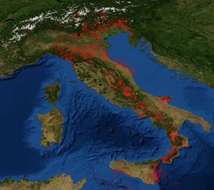
Ithaca Mapviewer